In this blog article, we will discuss about obligatory points in highway alignment.
Let’s begin!
Table of Contents
Introduction
Obligatory points in highway alignment are critical control points that dictate the route a highway must follow or avoid to ensure functionality, safety, and compliance with various constraints.
These points serve as guiding markers during the design process, determining where the alignment should pass to connect key locations or bypass restricted areas.
They encompass a range of factors, including topographical features, population centers, environmental considerations, and infrastructure requirements, shaping the highway’s path to balance engineering feasibility, cost, and societal impact.
Types Of Obligatory Points In Highway Alignment
There are two types of obligatory points in highway alignment.
- Positive Obligatory Points
- Negative Obligatory Points
We will discuss about these two types of obligatory points in detail.
1. Positive Obligatory Points
Positive obligatory points in highway alignment denote essential locations that a highway must incorporate to fulfill its operational, economic, and societal objectives. These points anchor the route, ensuring it connects vital destinations while optimizing functionality. They are meticulously identified to facilitate efficient transportation and regional development.
(a) Principal Urban Centers
Highway alignments are strategically designed to connect major cities or towns, which serve as focal points for economic and social activities. These centers, characterized by high population density and commercial activity, are integral to accommodating substantial traffic and fostering regional prosperity.
(b) Transportation Nodes
Critical infrastructure, such as airports, railway terminals, or maritime ports, must be integrated into highway routes. For instance, a highway may provide direct access to a port to streamline trade logistics or link a rail hub to enhance multimodal connectivity, thereby improving transport efficiency.
(c) Commercial Hubs
Alignments prioritize areas with concentrated economic activity, such as industrial estates or trade districts. By connecting these hubs, highways expedite the movement of goods and bolster commerce, exemplified by a route linking a logistics center to regional markets.
(d) Cultural and Touristic Sites
Significant landmarks, including historical monuments or natural attractions, are incorporated to promote tourism. A highway routed near a renowned cultural site can stimulate local economies by facilitating visitor access, thereby supporting community development.
(e) Favorable Topography
Geographic features, such as level plains or gradual inclines, are selected to minimize construction challenges. These terrains reduce the need for extensive earthworks, ensuring cost-effective development and sustainable maintenance of the highway infrastructure.
(f) Optimal Crossing Points
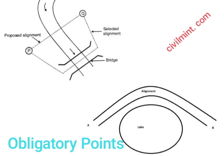
Specific locations conducive to crossing natural barriers, such as narrow waterways or low mountain saddles, are prioritised. A highway may traverse a stable, shallow river segment to simplify bridge construction or utilize a low pass to avoid complex engineering works.
(G) Regional Integration Points
Highways are aligned to connect administrative capitals or underserved rural communities, promoting equitable access. A route serving a remote area can enhance connectivity to essential services, such as healthcare or education, thereby advancing regional equity.
2. Negative Obligatory Points
Negative obligatory points in highway alignment refer to specific locations or features that a highway must avoid to ensure safety, cost-effectiveness, and compliance with environmental and regulatory standards. These points impose constraints on the route, requiring careful planning to circumvent them while maintaining the highway’s functionality. They are identified to minimize adverse impacts and engineering challenges.
(a) environmentally Sensitive Zones
Highways must steer clear of ecologically fragile areas, such as wildlife reserves or wetlands. These regions, often home to rare species or delicate ecosystems, require protection to preserve biodiversity. Routing through such zones could disrupt habitats and violate conservation mandates.
(b) Unstable Geological Areas
Terrains prone to natural hazards, like earthquake zones or landslide-prone slopes, are strictly avoided. Constructing highways in these areas risks structural failure and endangers travelers. Engineers opt for safer ground to ensure long-term stability and reduce maintenance burdens.
(c) Cultural Heritage Sites
Historical monuments, archaeological digs, or sacred sites must be bypassed to safeguard cultural legacy. A highway cutting through such areas could damage irreplaceable artifacts or provoke community opposition, necessitating alternative alignments to respect heritage values.
(d) Densely Populated Urban Centers
Highways are routed around heavily congested city cores to avoid exacerbating traffic and disrupting daily life. Passing through crowded urban zones often requires costly land acquisitions and poses safety risks, making bypass routes more practical.
(e) Critical Infrastructure
Existing utilities, such as high-voltage power grids or major pipelines, are avoided to prevent costly relocations or service interruptions. A highway crossing these assets could complicate construction and create operational hazards, prompting planners to find alternate paths.
(f) Challenging Topography
Steep cliffs, rocky outcrops, or deep gorges are excluded from alignments due to engineering difficulties. Building through such terrains demands extensive excavation or specialized structures, inflating costs and prolonging project timelines, thus warranting avoidance.
(g) Protected Agricultural Lands
Prime farmlands or irrigated fields are bypassed to preserve food production and minimize economic losses for farmers. Routing highways through these areas could reduce arable land and trigger compensation disputes, making non-agricultural routes preferable.
Conclusion
These negative obligatory points are pinpointed through detailed surveys, environmental assessments, and community consultations to ensure the highway alignment avoids undue harm.
By navigating around these constraints, planners create safer, more sustainable routes.