Digital elevation model is very popular 3-dimensional computer graphic technique that represents elevation of various objects in a single frame. In short form, it is known as DEM.
Digital elevation model is used to to represent various terrains with its objects. DEM is used to creates elevation of planets and satellites such as moon and asteroids.
Digital elevation model can be used to create topographic maps of land terrain and underwater terrain.
Table of Contents
Types of Digital Elevation Model
There are two types of digital elevation models are used as given below.
- Digital Surface Model (DSM)
- Digital Terrain Model (DTM)
We will discuss about these two types of digital elevation models.
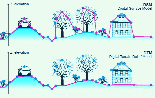
1. Digital Surface Model (DSM)
A digital surface model (DSM) is an elevation model that includes terrain elevation and ground features such as buildings, vegetation, towers, and other infrastructure. You can remove these ground features to create a digital elevation model of the bare ground.
A Digital Surface Model (DSM) captures surfaces including natural and man-made structures such as vegetation and buildings. They show the reflective surfaces of all features rising above the ‘bare ground’.
In other words, the DSM represents the surface of the Earth and all objects on it.
2. Digital Terrain Model (DTM)
Digital terrain model is the mathematical representation of the earth’s surface, often in the form of a regular grid with a unique elevation value assigned to each pixel.
A digital terrain model (DTM) is an elevation model of the earth’s surface. DTM does not include functionality beyond the surface of the earth, nor does it include permanent functionality.
Therefore, we can combine them with DSM to get the height information of objects on the surface. Some consider DTMs to be extensions of DEMs, which are networks of vector points of terrain features rather than continuous grids.
Some important terms to keep in mind when working with elevation models are ground, elevation, land, and terrain.
Uses of DEM
- Extract terrain parameters for topography.
- Water flow modeling for hydrology or mass motion.
- Soil wetness modeling with cartographic water depth index.
- Creating a relief map.
- 3D visualization rendering.
- 3D Flight Planning.
- Creation of physical models.
- Modifying aerial or satellite imagery.
- Reduction of gravitational measurements.
- Terrain analysis in geomorphology and physical geography.
- Geographic Information System (GIS).
- Engineering and infrastructure design.
- Satellite navigation.
- Gaze analysis.
- Base mapping.
- Flight simulation.
- Train simulation.
- Precision agriculture and forestry.
- Surface analysis.
- Intelligent Transport System (ITS)