In this article, you will learn about the plane table survey. This type of survey is very fast because field measurement and plotting can be done simultaneously.
Let’s get started.
Table of Contents
What is Plane Table Survey?
A plane table survey is one of the fastest methods of surveying. A Surveyor can do plotting of plan and field monitoring both at the same time. In the plane table surveying, the geometrical situation of the site is plotted on the map paper using a plane table and alidade, and then topographic details are created on the map.

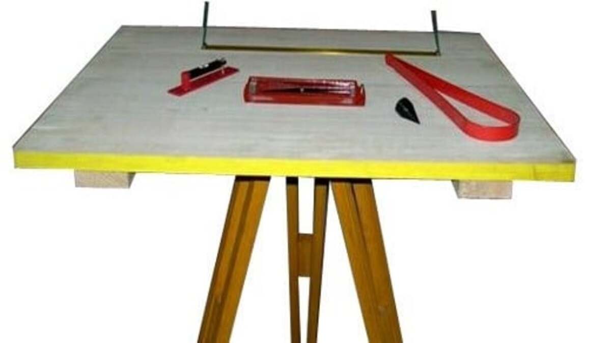
Plane Table Survey Equipments:
To perform a plane table survey, some equipment, tools, and objects are required. Here is the complete list of required things to perform a plane table survey.
- Plane Table
- Plumb bob
- Plumb fork
- Alidade for Sighting
- Tripod
- Drawing sheets and drawing tools
- Paper clips and screws
- Compass
- Spirit level
- Chain
Plane Table Working Arrangement:
Plane Table Fixation:
- On the tripod stand fix the plane table.
- Drawing sheets are arranged on the plane table using paper clips.
- Drawing sheets are to be positioned from first to last.
Leveling:
- The plane table should be leveled by using Spirit level,
- For small works, eye evaluation should be good.
Centering:
- Centered with the help of a plumbing fork.
- We can use a plumbing fork to arrange plotted point over the ground point.
Orientation:
- Orientation is needed when we use more than one instrument station.
- Back sighting and compass are the essential tools to do orientation.
- By rotating the plane table so that plotted lines in the drawing sheets will be parallel to lines on the ground.
Plane Table Surveying Methods:
- Radiation
- Traversing
- Resection
- Intersection
Radiation:
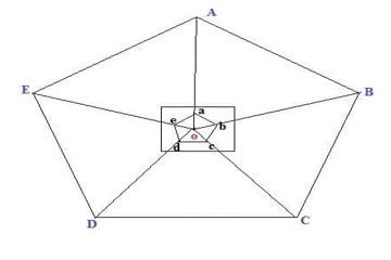
According to the radiation method, we locate the plane table at point “O” as shown below. Sight the point A, B, C, D, E by alidade, at that point we plot focuses a,b,c,d,e in the drawing sheet.

Traversing:
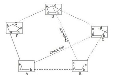
In this method, straight lines are connected in series. The plane table is located at one point A as shown in the figure from that point of view towards B and measures the distance AB. Now move the plane table to point B and view towards A and measure BA. At that point C from B and measure BC and repeat the same process until the last point. At last, you will get the traverse lines.

Resection:
In this process of plane table surveying, the location of the plane is unknown and can be dogged by sighting it to plotted points. It can be done by two field conditions that are:
- Three-Point Problem
- Two-point Problem
Intersection:
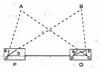
From two known stations two-point rays are to be plotted to locate the point. Let us assume P and Q are the known stations. We first put the equipment on P and plot the lines by sighting stations A, B, and P. At last intersecting lines of A and B rays get us the location that is required.

Merits and Demerits of Plane Table survey
It is a Graphical surveying process using a plane table, by which a surveyor does both the plotting and fieldwork work at the same time. One of the greatest merits of the plane table is that the topographic features are mapped in full view.
From this article, we will let us know all the major merits and demerits of the plane table survey.
Advantages of Plane table Survey:
- For small scale mapping, it is the most appropriate method of surveying.
- It can discard all the machine and human blunders because the plotting and surveying are done at the same time on site.
- Plane table surveying gets its significance in the sites where magnetic fluctuations are high and compass survey is not certain.
- Plane table survey is the fastest surveying techniques.
- Elimination of errors that occurs due to human mistakes in field book entry is easy.
- To plot a map does not require any skilled person.
- Contours and different irregular objects are perfectly represented on the map as the tract is in the sight.
- Errors and inaccuracy during plotting are checked by drawing check lines.
- It is one of the cheapest methods of surveying as it does not require any Surveying machines.
Disadvantages of Plane Table Survey:
Some of the Demerits of the plane table survey are as follows:
- It is very lengthy and difficult to shift and re-orient the plane table from one place to another
- Plane table surveying is not convenient in raining and windy places as the work of plotting are done on the field only.
- To carry a plane table and its parts are not easy.
- The accuracy in the plane table survey is not much high as compared to other types of surveying methods.
- When the survey is to replotted to other scale or quantities are to be calculated, it will be a great inconvenience in the absence of the field notes
- For Surveying large areas it is not suitable.
- The plane table surveying method is not convenient in dense forest areas because the trees are very close and block the sight of an important part of the field.
- You can use this method of surveying only in the daylight.
Uses Of Plane Table Surveying
Some of the key applications of plane table surveying include:
- Urban Planning: Plane table surveying is an essential tool for urban planners and architects as it enables them to create accurate and detailed plans of a specific area. The method can be used to map the location of buildings, roads, and other structures, providing valuable information for urban development projects.
- Topographic Surveying: Plane table surveying is also used in topographic surveying, which involves mapping the elevation and relief of an area. The method can be used to create detailed topographic maps, which are essential for engineering, construction, and land-use planning.
- Archaeological Surveying: Plane table surveying is a critical tool for archaeologists as it allows them to accurately record and map archaeological sites. The technique enables them to create detailed maps of historical ruins and other archaeological features, providing valuable insights into the past.
- Site Layout: Plane table surveying can be used to layout the construction site, providing all the necessary information on the location of buildings, roads, and other structures, This can be useful in construction project management as it helps to plan the project, estimate the cost and allocate resources in an efficient way.
- Photogrammetry: Plane table surveying can be combined with photogrammetry to create highly detailed 3D models of an area. This technique is particularly useful in applications such as surveying large construction sites or mapping large areas of natural terrain.
- Mapping small areas: Plane table surveying is also useful for creating detailed maps of small areas such as a town or city block, this can be helpful for both urban planning and architecture.
Conclusion:
I hope you have enjoyed my article on the plane table survey. It is very important for land surveyors to know different types of surveys.
I have listed some articles on the land survey. You can check out these articles to gain some more knowledge.
Faqs
A plane table survey involves creating a small-scale map of an area using a plane table, alidade, and other surveying equipment. The surveyor will set up the plane table on a tripod and use the alidade to take bearings on various points in the survey area. These bearings are then plotted on the plane table to create a map of the area.
Common instruments used in a plane table survey include a plane table, alidade, spirit level, tripod, and a set of drawing instruments such as pencils and rulers.
There are several methods of plane table surveying including traversing, radiation, and intersection. Traversing involves taking a series of bearings on points in the survey area, while radiation involves taking bearings on points from a central location. Intersection involves taking bearings on a point from two different locations.
Plane table surveying has several benefits such as its portability, the ability to survey in difficult terrain and the ability to create a small-scale map of an area quickly.
Plane table surveying is often used for mapping small areas, reconnaissance surveys and for surveying in remote locations.
One limitation of plane table surveying is that it may not be as accurate as other surveying methods such as total station surveying.
There are several potential sources of error in plane table surveying such as measurement errors, errors in plotting, and errors in orientation.
Total station surveying is generally considered to be the most accurate surveying method.
Traversing is the most commonly used method in plane table surveying.
The two point problem in plane table surveying refers to the process of determining the position of a point on a map by measuring the angles to that point from two other known points. It is a technique used to establish the location of an unknown point by measuring angles to it from two known points.
Read More Articles on Survey:
