Azimuths and bearings are horizontal angles measured to indicate or locate a line with respect to a meridian. Here, the important features of azimuth and bearing in surveying along with their comparison are explained completely.
Table of Contents
What is Azimuth in Survey?
Azimuths are defined as horizontal angles that are measured from the reference meridian in the clockwise direction. Azimuths are also called the whole circle bearing systems (W.C.B). Azimuths are utilized in compass surveying, plane surveying, where they are normally measured from the north. In astronomy and in the military azimuths are measured from the south.
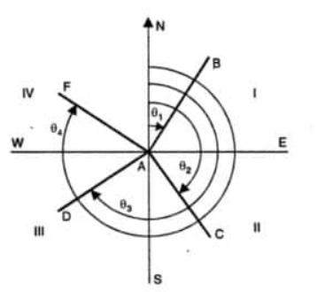
The above figure shows the measurement of azimuth from the north direction. It is clear from the above figure that every line has an azimuth value ranging from 0 to 360 degrees.
Based on the meridian used, the azimuths can be either geodetic, astronomic, assumed, record, or magnetic by nature. It is always suggested to state the reference meridian before starting the surveying work so that later confusion can be avoided.
Forward azimuth gives the forward direction of the line, while backward azimuth gives the forward direction of the line. The forward azimuth can be converted into a back azimuth by adding or subtracting 180 degrees.
If line AB has an azimuth of 70 degrees which is the forward azimuth then the backward azimuth will be 70+180 = 250 degrees. If the azimuth of the line AD is 230 degrees, then the backward azimuth is 230-180 = 50 degrees (From the above figure).
Azimuth is utilized in boundary, control surveys, topographic surveys, and other types of surveys.
What is Bearing in Survey?
The acute angle that is measured between the reference meridian and the given line is known as the bearing. The line is measured either from the north or south towards east or west which would give an angle less than 360 degrees. The angle is indicated by N or S first followed by angle value and E or W direction, For example, N60E.
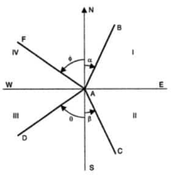
Quadrantal Bearing Systems or Bearings
From the above figure, the bearing of line AB is less than 90 degrees as it lies in the first quadrant NE.
A magnetic bearing is measured from the local magnetic meridian, grid bearing from a suitable grid meridian, assumed bearings from a suitable arbitrary meridian, geodetic bearing from a geodetic meridian, and an astronomic bearing from an astronomic meridian. The magnetic meridian is acquired by observing the needle of the compass.
Difference between Azimuths and Bearings in Surveying
| S.N | Azimuths | Bearings |
|---|---|---|
| 1 | value can vary from 0 to 360 degree | value can vary from 0 to 90 degree |
| 2 | It is indicated by the numerical value | It is indicated by two letters and the numerical value |
| 3 | The angles are measured in clockwise direction only | The angles are measured in both clockwise and anticlockwise direction |
| 4 | A single set of measurements is taken either from North or South | Angles can be measured either from north or south for a single survey |
Comparison of Bearings and Azimuths in Surveying
Determination of Azimuths and Bearing
Given the quadrant in which the line lies and provided the value of azimuth or bearing can help to determine the other value.
| Quadrant | Bearing to Azimuth Conversion |
| I (NE) | Bearing = Azimuth |
| II(SE) | Bearing = 1800 – Azimuth |
| III(SW) | Bearing = Azimuth – 180 degree |
| IV (NW) | Bearing = 360 – Azimuth |
Dear sir ,
Do you have any blog to learn total station survey ?
You can read the Total Station Survey on this blog.