Table of Contents
Introduction of Reconnaissance Survey
Reconnaissance Survey is performed to determine the best possible routes for roads or airfields. Reconnaissance survey is conducted for a large area. It can be locality, town or empty area. Reconnaissance survey is done for a large area that is why various routes can be find. But the main purpose of this survey is to find out the best route.
One of the first steps in reconnaissance is to collect and survey all available maps of the area to be covered. Getting the most desirable line during exploration can save a lot of time and money on wasted equipment surveys. A detailed survey of the entire area should be conducted to ensure that no potential route has been overlooked.
Reconnaissance survey work should be left to experienced technicians. Locator engineers employ a rare combination of technical thoroughness, business acumen, judgment and foresight to enable the selection of routes that meet future demand, within the limits of economic justification.
Purpose of Reconnaissance Survey
- The primary pupose is to obtain geotechnical and topographical information of the area.
- To find out best routes.
- It is also used for earthwork.
- Another important purpose is to identify various religious places like temple and mosque.
- It is used to protect heritage sites and historical buildings.
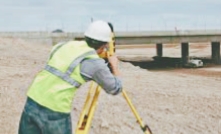
Intelligence Tools to Perform Survey
Distance is usually taken from a reference map or can be roughly determined by pace or pedometer if exploration is on foot. The direction of the line can be observed using a prismatic compass. A kind of compass for rough terrain and wooded areas. Essential for field reconnaissance. The relative elevation of a point can be determined directly from the topographic map if possible. If no such map is available, an aneroid barometer can be used to determine altitude. Recent improvements to the aneroid have given the technician access to an instrument that allows him to measure height differences with an accuracy of 1 to 1 m.
The relative slope, or approximate height difference, of the ground can be obtained using a level or inclinometer. Notes and records can be marked directly on an existing map, or notes can be kept separate in narrative form.
Reconnaissance maps, either sketched on existing maps or created separately, should show individual viable routes, checkpoints, key topographical features, and other details to aid in route selection.
How to Find Best Route in Reconnaissance Survey?
2-3 best possible routes are selected based on permiminary survey. Thsese routes are used for extensive study. Topographical maps and aeronautical charts are used to determine best path. The use of modern methods can minimize the effort of time-consuming exploration and preliminary surveys.
In valley locations, the route follows local valleys and drainage ditches, with few excessive slopes. There is often a risk of land subsidence and flooding. Multiple bridges may be required to cross tributaries. More advantageous locations are often reached by traversing the valley at strategic points, so route exploration should include the entire valley. For cross-country entries, the line is on the other side of the drainage channel. Such lines frequently cross ridges and become steeper. Construction costs along such lines can also be excessive. Locations along ridges have relatively few drainage problems and major drainage structures. However, since ridges are rarely straight, it may be necessary to use significant curvature at such points. Also, if the site falls into a valley or recovers on a ridge, steep slopes will occur.
Conclusion
Reconnaissance survey shoud perform very carefully. Error in survey points can lead to bad survey report. Experienced engineers should perform reconnaissance survey.